![](/images/other/stat-length.png)
![Tour Zu Fuß Bezirk Trentschin - Mitická dvadsiatka - TRASA A – 20 km - Photo](https://media.geolcdn.com/t/1900/400/226136a2-7a13-4dbd-9b0a-4d3f6e52a39b.jpeg&format=pjpeg&maxdim=2)
Mitická dvadsiatka - TRASA A – 20 km
SityTrail - itinéraires balisés pédestres
Tous les sentiers balisés d’Europe GUIDE+
![Länge](/images/other/stat-length.png)
Länge
8,8 km
![Maximale Höhe](https://static1.geolcdn.com/siteimages/upload/files/1508320355ic_sort_altitude_max_24dp.png)
Maximale Höhe
769 m
![Positive Höhendifferenz](https://static1.geolcdn.com/siteimages/upload/files/1508320355ic_sort_den_pos_24dp.png)
Positive Höhendifferenz
551 m
![Km-Effort](/images/other/stat-length.png)
Km-Effort
15,5 km
![Min. Höhe](https://static1.geolcdn.com/siteimages/upload/files/1508320355ic_sort_altitude_min_24dp.png)
Min. Höhe
307 m
![Negative Höhendifferenz](https://static1.geolcdn.com/siteimages/upload/files/1508320355ic_sort_den_neg_24dp.png)
Negative Höhendifferenz
361 m
![Boucle](https://static1.geolcdn.com/siteimages/upload/files/16400158638029165_repeat_loop_refresh_sync_direction_icon.png)
Boucle
Nein
Kennzeichnung
Erstellungsdatum :
2025-02-06 15:24:48.69
Letzte Änderung :
2025-02-06 15:24:48.69
![Zu Fuß](https://static1.geolcdn.com/sitytour/trail-icons/100.png)
3h31
Schwierigkeit : Einfach
![Scannen Sie diesen QR-Code, um die Tour in der SityTrail-Anwendung zu öffnen](https://capi.geolives.com/qq0zvz2zws4bq2lad0pu/sitytour/trails/4343416/qr.png?size=200)
Kostenlosegpshiking-Anwendung
Über SityTrail
Tour Zu Fuß von 8,8 km verfügbar auf Trentschiner Landschaftsverband, Unbekannt, Bezirk Trentschin. Diese Tour wird von SityTrail - itinéraires balisés pédestres vorgeschlagen.
Beschreibung
https://www.trencianskemitice.sk/oznamy/miticka-dvadsiatka-2018.html
Symbol: major
Website: https://www.trencianskemitice.sk/oznamy/miticka-dvadsiatka-2018.html
Ort
Land:
Slovakia
Region :
Trentschiner Landschaftsverband
Abteilung/Provinz :
Unbekannt
Kommune :
Bezirk Trentschin
Standort:
Trenčianske Mitice
Gehen Sie:(Dec)
Gehen Sie:(UTM)
287998 ; 5410486 (34U) N.
Kommentare
Touren in der Umgebung
![Tour Zu Fuß Bezirk Trentschin - Jastrabská](https://media.geolcdn.com/t/375/260/f5d2ba1c-1e38-4c67-a22d-c29bd6bc1e9a.jpeg&format=jpg&maxdim=2)
![Zu Fuß Zu Fuß](https://static1.geolcdn.com/sitytour/trail-icons/100.png)
Jastrabská "25"
Zu Fuß
Einfach
Bezirk Trentschin,
Trentschiner Landschaftsverband,
Unbekannt,
Slovakia
![](/images/other/stat-length.png)
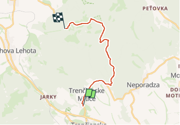
10,7 km | 16,6 km-effort
3h 46min
![](https://static1.geolcdn.com/siteimages/upload/files/16400158638029165_repeat_loop_refresh_sync_direction_icon.png)
Nein
![Tour Zu Fuß Bezirk Trentschin - Mitická dvadsiatka - TRASA D – 25 km - Photo](https://media.geolcdn.com/t/375/260/52631547-5193-4600-bf87-dfcdf8992972.jpeg&format=jpg&maxdim=2)
![Zu Fuß Zu Fuß](https://static1.geolcdn.com/sitytour/trail-icons/100.png)
Mitická dvadsiatka - TRASA D – 25 km
Zu Fuß
Einfach
Bezirk Trentschin,
Trentschiner Landschaftsverband,
Unbekannt,
Slovakia
![](/images/other/stat-length.png)
6,9 km | 10,4 km-effort
2h 22min
![](https://static1.geolcdn.com/siteimages/upload/files/16400158638029165_repeat_loop_refresh_sync_direction_icon.png)
Nein
![Tour Zu Fuß Bezirk Trentschin - Mitická dvadsiatka - TRASA B – 10 km - Photo](https://media.geolcdn.com/t/375/260/226136a2-7a13-4dbd-9b0a-4d3f6e52a39b.jpeg&format=jpg&maxdim=2)
![Zu Fuß Zu Fuß](https://static1.geolcdn.com/sitytour/trail-icons/100.png)
Mitická dvadsiatka - TRASA B – 10 km
Zu Fuß
Einfach
Bezirk Trentschin,
Trentschiner Landschaftsverband,
Unbekannt,
Slovakia
![](/images/other/stat-length.png)
4,9 km | 7,9 km-effort
1h 48min
![](https://static1.geolcdn.com/siteimages/upload/files/16400158638029165_repeat_loop_refresh_sync_direction_icon.png)
Nein
![Tour Zu Fuß Bezirk Trentschin - Náučný chodník potok Svinica a okolie - Photo](https://media.geolcdn.com/t/375/260/ext.jpg?maxdim=2&url=https%3A%2F%2Fstatic1.geolcdn.com%2Fsiteimages%2Fupload%2Ffiles%2F1545311037marcheuse_200dpi.jpg)
![Zu Fuß Zu Fuß](https://static1.geolcdn.com/sitytour/trail-icons/100.png)
Náučný chodník potok Svinica a okolie
Zu Fuß
Einfach
Bezirk Trentschin,
Trentschiner Landschaftsverband,
Unbekannt,
Slovakia
![](/images/other/stat-length.png)
3,3 km | 4,4 km-effort
59min
![](https://static1.geolcdn.com/siteimages/upload/files/16400158638029165_repeat_loop_refresh_sync_direction_icon.png)
Nein